Know before you're stuck at the tracks.
Drive normally. Crossbuck warns you when a railroad crossing ahead may be blocked, and shows which crossings are usually blocked, and when.
Coming soon toiPhone
Coming soon toAndroid
No account needed.
Example · Houston
Eastwood Street crossing
Most often blocked 9–11 PM
909 blockage reports in the past year.
See this crossingBy the numbers
Every crossing in America, before you get there.
- railroad crossings mapped
- 202,266
- railroad crossings mapped
- states covered
- 50 + DC
- states covered
- blockage reports analyzed
- 55,843
- blockage reports analyzed
- crossings with blockage history
- 11,771
- crossings with blockage history
Federal Railroad Administration data, Sep 2024 – Aug 2026. Rows repeated in FRA's feed are counted once. Updated Sep 22, 2026.
Crossbuck drivers
Starts at zero on launch day
- Drivers
- —
- Blockages flagged
- —
- Heads-ups sent
- —
- Took the way around
- —
- Minutes saved
- —
How we count
These numbers only count real, verified activity, so they start at zero on launch day. No estimates dressed up as counts, no rounding up.
- Drivers:
- People who used Crossbuck in the last 30 days.
- Blockages flagged:
- Crossings our drivers' phones detected as likely blocked.
- Heads-ups sent:
- Warnings delivered to drivers heading toward a flagged crossing.
- Took the way around:
- Drivers who got a heads-up and verifiably avoided the crossing.
- Minutes saved:
- For each driver who took the way around: how much longer the crossing stayed blocked after they would have arrived, minus the detour. Counted conservatively.
The problem
Most blocked crossings aren't a passing train. They're a parked one.
- 6 in 10
- reported blockages lasted more than 30 minutes
- 88%
- involved a train that wasn't moving
- 1 in 5
- reports said emergency responders couldn't get across
- 30%
- came from crossings on school bus routes
These are only the reports. For every one filed, an estimated 50+ drivers waited and said nothing.* We never reported one either.
* Estimate: each crossing's average daily traffic (FRA inventory) × the shortest possible length of each reported blockage, divided by the number of reports; median across 43,000 blockages. Source: Federal Railroad Administration, Public Blocked Crossing Incident Reporter, Sep 2024 – Aug 2026.
Where it happens
Blocked crossings cluster in a few places.
Each dot is a crossing reported blocked five or more times since Sep 2024. Bigger dots, more reports. Houston alone had 11,500+ reports, more than the next six metro areas combined.
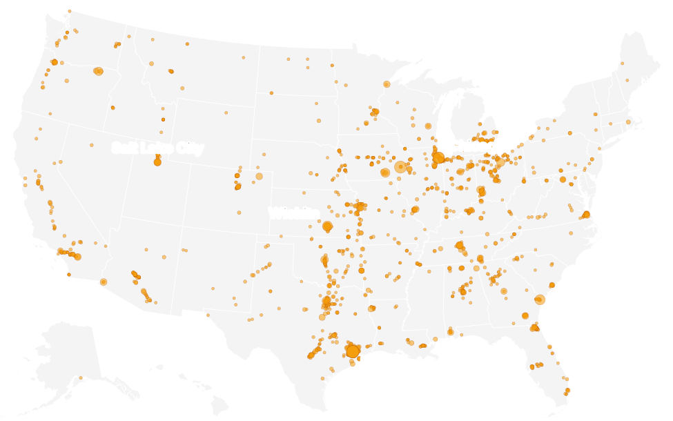
Most-reported areas
- Houston, TX11,546 reports
- Chicago, IL3,800 reports
- Wichita, KS1,799 reports
- Dallas–Fort Worth, TX1,622 reports
- Detroit, MI1,229 reports
- Nashville, TN1,110 reports
- Salt Lake City, UT1,069 reports
- Cincinnati, OH1,007 reports
How it works
How Crossbuck helps
1
Know the usual suspects
See which crossings near you get blocked, and at what times of day, from two years of federal reports.
2
Hear about it before you get there
When drivers using Crossbuck are stopped at a crossing, drivers heading that way get a spoken heads-up.
3
Take the way around
Open a route in Google Maps or Apple Maps to the nearest bridge or underpass.
Privacy
Private by design
- Your GPS trail stays on your phone. Crossbuck only shares that a crossing looks blocked, not where you've been.
- No account needed. Sign in with Apple or Google only if you want to keep your history when you change phones.
The name
Why “Crossbuck”?
The crossbuck is the white X sign at every public railroad crossing in America. We named the app after it because that's where it helps: at the crossing, before you're stuck at it.
Drive normally. We'll watch the crossings.
Coming soon toiPhone
Coming soon toAndroid